From an Unsafe Route to a Fundable Project
From an Unsafe Route to a Fundable Project
How Kentucky communities can turn a transportation concern into a plan for safer walking, biking and everyday movement
Most active transportation projects begin with a problem people can already see. A sidewalk ends before reaching a school. A busy road separates a neighborhood from a park. A dangerous crossing makes a short trip feel impossible. A trail stops just short of downtown, or a shoulder disappears where people most need it.
Recognizing the problem is important, but communities often struggle with what comes next. Residents may know a route feels unsafe without knowing who controls the road, what kind of improvement is needed or how a concern becomes eligible for funding.
The path from frustration to construction is rarely immediate, but it is more manageable when communities begin with clear documentation, the right partners and a realistic planning process.
Begin with the trip people are trying to make
Before discussing a specific solution, start by identifying the trip that is not working. Who is trying to travel, where are they going and what prevents them from getting there safely?
The concern may involve children walking to school, residents trying to reach a park, employees traveling between a neighborhood and a workplace or people using wheelchairs and other mobility devices to access daily services.
This approach keeps the conversation grounded in community life rather than beginning with a preferred project. A missing sidewalk may be the obvious problem, but the broader need could involve a difficult crossing, poor lighting, excessive vehicle speed or a lack of connection between existing routes.
A useful project description explains not only what is missing, but how that gap affects real people and everyday destinations.
Determine who is responsible for the road
One of the first practical questions is also one of the most important: Who owns or maintains the route?
Responsibility may belong to the Kentucky Transportation Cabinet, a city government, a county government or, in some cases, a property owner responsible for an adjacent sidewalk segment. The correct starting point depends on the road and the type of improvement being considered.
Local streets are generally managed through city or county processes, while state routes require coordination with the appropriate Kentucky Transportation Cabinet district office. Projects involving more than one jurisdiction may require several partners to work together.
Understanding ownership helps communities direct concerns to the right people, learn which planning cycles apply and avoid spending time pursuing a solution through an agency that does not control the route.
Document the need clearly
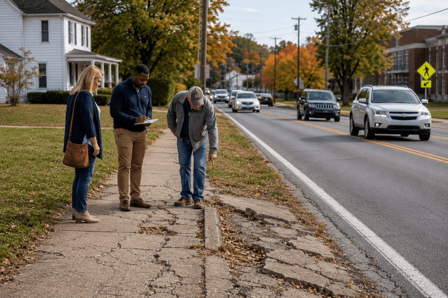
Communities are more likely to move a project forward when they can demonstrate the problem with evidence. Documentation helps transform a general concern into something planners, engineers and funding partners can evaluate.
Useful information may include:
- Photographs and video of the route
- Locations of missing sidewalks or unsafe crossings
- Vehicle speed information
- Crash history
- Community feedback
- Proximity to schools, parks, downtown areas and essential services
- Accessibility barriers and ADA concerns
- Times of day when the route is most heavily used
- Existing plans or studies that mention the area
Documentation does not need to be technical at the beginning. Residents can photograph where a sidewalk ends, note how long a crossing signal lasts or describe why families avoid a particular route.
The goal is to establish that the concern is specific, recurring and connected to a meaningful community need.
Connect the project to an adopted plan
Transportation improvements are rarely funded simply because they are good ideas. Projects are more competitive when they are included in an adopted plan and connected to broader community goals.
That plan might be a bicycle and pedestrian master plan, comprehensive plan, downtown plan, parks plan, corridor study, ADA transition plan or transportation improvement program. Inclusion in planning documents shows that the project has been reviewed, discussed and identified as a community priority.
Planning also helps communities consider how one improvement fits within a larger network. A single sidewalk may solve an immediate problem, but a connected route linking neighborhoods, schools, businesses and public spaces can create greater long-term value.
This is why planning often comes before funding. A strong plan creates a shared direction, clarifies priorities and gives local leaders a foundation for pursuing grants and other resources.
Choose the right planning tool
Not every concern requires the same process. The appropriate next step depends on how clearly the problem and solution are understood. A community may need:
- A walk-bike master plan to establish a broader network and priorities
- A feasibility study to determine whether a proposed connection can work
- A corridor study to evaluate safety and access along a specific route
- A safety audit to identify hazards and possible countermeasures
- An ADA transition plan to address accessibility barriers
- Preliminary design or engineering to develop a project beyond the concept stage
- Cost estimates to prepare for budgeting and funding applications
Some communities begin by asking for construction funding when they are still uncertain about the project’s location, design or cost. In those cases, planning and feasibility work may be the more appropriate first investment. Technical assistance can help communities define the project well enough to pursue implementation with greater confidence.
Bring the right people into the conversation
Transportation projects move more effectively when the people affected by the route are connected with the agencies and professionals who can help address it. Potential partners may include:
- City or county planners
- Local elected officials
- Kentucky Transportation Cabinet district staff
- Area Development District staff
- Public health departments
- School representatives
- Parks and recreation departments
- Tourism and downtown organizations
- Engineering consultants
- Business owners
- Neighborhood groups
- Walking and bicycling advocates
- Residents who use the route
Each partner brings a different perspective. Residents can explain how the route functions in daily life. Public health professionals can connect the project to physical activity and community health. Planners can identify relevant policies and plans, while engineers can evaluate technical options.
Early collaboration can also reveal opportunities that one organization may not see alone, including related projects, available studies, potential funding sources or upcoming road work that could incorporate an improvement.
Start with achievable improvements when possible
Not every safety concern requires a major construction project. Some communities can make meaningful progress through smaller improvements while longer-term plans continue. Possible early actions may include:
- Filling a short sidewalk gap
- Refreshing pavement markings
- Improving signs
- Trimming vegetation that blocks sight lines
- Adjusting crossing signal timing
- Adding lighting
- Repairing curb ramps
- Improving a trail connection
- Addressing debris or maintenance problems
- Enhancing visibility at a crossing
These improvements should not replace needed long-term investment, but they can reduce immediate barriers and demonstrate progress.
Smaller projects can also build public confidence. When residents see a documented concern lead to a visible improvement, they are more likely to participate in future planning and advocacy.
Understand how projects are prioritized
Communities often have more transportation needs than they can address at one time. Projects are therefore evaluated against several factors, including safety concerns, crash history, proximity to important destinations, community demand, alignment with adopted plans and available funding.
A project near a school, park or downtown area may receive greater attention because it serves many users or connects important destinations. A documented history of crashes or dangerous vehicle speeds may also strengthen the case for action.
Community support matters, but support becomes more useful when it is organized around clear evidence and a specific request. A collection of photographs, written experiences and documented barriers is more actionable than a general statement that a road feels unsafe.
The stronger the documentation and planning alignment, the easier it becomes for local leaders and agency partners to explain why a project should move forward.
Match the project with the appropriate funding path
Funding may come from local capital budgets, Kentucky Transportation Cabinet project coordination, federal transportation programs, grants or public-private partnerships.
The right source depends on the project’s size, ownership, readiness and purpose. A small local crossing improvement may be handled differently from a multi-mile trail, a state highway reconstruction or a complete bicycle and pedestrian network.
Major projects often move through several stages, including planning, preliminary design, environmental review, cost estimation, funding allocation, engineering and construction. Each stage may take time, especially when multiple agencies or funding sources are involved.
That timeline can be discouraging, but careful preparation improves a community’s ability to respond when funding becomes available. A clearly documented, planned and supported project is far more competitive than an idea that has not yet been developed.
Active Living support can help communities move forward
Kentucky’s State Physical Activity and Nutrition Program supports active living by helping communities create environments where walking, bicycling and other forms of everyday movement are safer and more practical.
That work can include support connected to walk-bike master planning, feasibility studies, design projects and other efforts that help communities understand their needs and prepare for future improvements.
Communities do not need to arrive with a finished project or a fully developed technical solution. A productive first step may simply be identifying the route, documenting the concern and beginning a conversation with local leaders and planning partners.
Active living is not limited to recreation. It includes walking to school, biking to work, reaching a park or completing an everyday trip without always relying on a vehicle. Planning for those trips can support physical activity, safety, access and community connection.
Progress begins by making the problem visible
An unsafe route can feel permanent when residents have encountered it for years. The missing sidewalk, dangerous crossing or disconnected path may become so familiar that people stop imagining another possibility.
Projects begin to move when communities make the problem visible, connect it to real trips and place it within a process that local leaders and funding partners can act upon. The first step may be a photograph, a conversation or a note added to a planning meeting agenda. From there, communities can identify ownership, gather evidence, involve partners and determine which planning tool will help define the solution.
Construction may not happen quickly, but progress becomes possible when a concern is transformed into a documented need, a shared priority and a project ready for the next opportunity.